

Project Goals
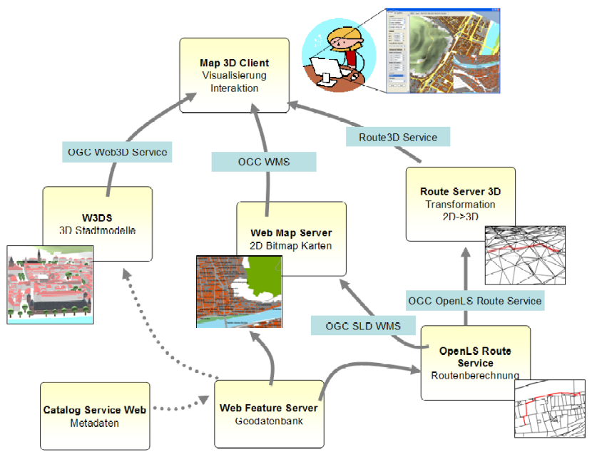
Within the project SDI-3D, we implement an SDI for the city of Heidelberg. It has access to all available geodata sources and provides components for the visualization through the Internet. We rely on the specifications of the Open Geospatial Consortium (OGC), which defines standards for spatial services that have been accepted internationally. However, sometimes we need to extend existing OGC standards, since they are not suited for a 3D SDI, or we need to foster the development of new services. Therefore, the experiences gained during the project will be incorporated into the standardization process of the OGC. In this context the Web3D Service (W3DS) is of particular importance, which, as a counterpart to the Web Map Service (WMS), provides 3D maps or scenes for an interactive visualization. The W3DS contains the complete city and landscape model and is accessible as open internet service.
The modelling of the city model is carried out on the one hand on the basis of official data courtesy of the land surveying office like the terrain model, building footprints coming from the cadastre, trees, and information on the traffic infrastructure. On the other hand we continuously capture objects with a higher level of detail. The goal is to have highly detailed and textured models for all landmarks and areas that are of interest for tourists. Furthermore we capture: roof shapes, land use areas, city furniture, wells, statues, and other things. Therefore the city model can be used for a cartographic portrayal containing information on streets, infrastructure, sights for tourists, and recreational facilities, as well as for VR applications that require a more realistic display.
The model comprises:
- LOD 0: DEM, landscape model, contains land use areas or aerial photographs
- LOD 1: building blocks
- LOD 2: buildings with roof shapes
- LOD 3: buildings with roof shapes and facade textures as well as detailed landmark models
© 2010 University of Heidelberg, Department of Geography, GIScience